
| MAFLA Formation |
|
|
|
|
|
|
|
|
|
|
|
|
|
|
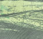
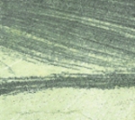
Cross-Bedded
Oomoldic Porosity
(Oomolds / Porosity
Stained Black;
Cream-Colored
Areas Represent
Nonporous Micrite)
Oomoldic Analog
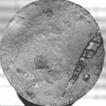
Smackover Core
With Stylolite
And Gastropod
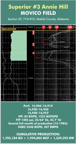
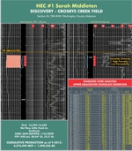
Low-Resistivity Oil Pay
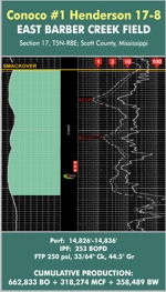
Low-Resistivity Oil Pay
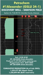
Low-Resistivity Oil Pay
PROLIFIC SOURCE ROCK AND RESERVOIR
Oil was first discovered in the Jurassic Smackover when a "deep" test was drilled in the shallow Smackover Field in Union County, Arkansas in 1937. With that notable discovery, the Smackover became one of the most sought-after Jurassic objectives in the Gulf Coast. The Smackover Formation does not outcrop and is only encountered in subsurface penetrations located in the U.S. Gulf Coast area.
Within that region, the Smackover is a carbonate facies that grades laterally into an evaporitic facies in certain areas of the Mississippi Interior Salt Basin. Typically, within the Middle and Upper Smackover, reservoir porosity grades upward from algal and thrombolitic boundstones to higher energy peloid and ooid grainstones and lateral sabkha equivalents. Some of the localized facies changes can be abrupt; for example, in Clarke County, Alabama, the upper 150 to 200 feet of the Smackover grades laterally (and abruptly) into a series of anhydrite and halite beds - resulting in the juxtaposition of a shallow-water restrictive lagoonal area with what appears to be an algal barrier reef.
Further west, localized sabkha facies grade into more "open-water" (but apparently, highly saline) oolitic grainstones in central Choctaw County, Alabama. Proximity of these upper Smackover grainstones to magnesium-rich brines associated with lateral sabkha equivalents and overlying Buckner anhydrites led to extensive dolomitization of the oolitic, peloidal, and oncolitic grainstones. The resulting oomoldic and pelmoldic dolomite is exceptionally porous but uniformly low in permeability. The low permeability results from the following diagenetic mechanism, focusing on oomoldic reservoirs only in this simplified example: (1) aragonitic ooids are deposited; (2) calcite cement precipitates within, and effectively occludes, the pore space between the ooids; (3) the aragonitic ooids are then "preferentially" leached out, leaving void spaces ("molds") where the spherical ooids once were, encapsulated in the very calcite cement that had earlier occupied all interstitial pore space - effectively leaving only the calcite cement matrix; finally, (4) the remaining calcite cement is extensively dolomitized, creating an incredibly fine matrix of oomoldic porosity.
The presence of the large ooid molds creates significantly high porosity (depending of course upon the size of the original ooids), however, the dolomitization of the once impermeable calcite cement creates what this geologist refers to as "fractal" permeability - micropermeability so uniformly fine as to create a latticework that, while "poor" by normal standards, is well-suited to the production of gas and gas liquids. However, such micropermeability is not conducive for the commercial production of oil, and most attempts to produce oil from the Upper Smackover oomoldic dolomite facies in Mississippi and Alabama have failed.
To view a prolific example of gas-condensate productive Smackover oomoldic porosity, click here.
Significant opportunities still exist for the discovery and development of oomoldic gas-condensate reservoirs within the Alabama/Mississippi Smackover Trend because many explorers are unfamiliar with such reservoirs, their characteristics, and their hidden potential.
Algal patch reefs are also observed within the Upper Smackover, especially in southwest Alabama. The algal facies within both the Upper and Lower Smackover is especially noted for good porosity and very good permeability, especially when dolomitized, because dolomitization of the algal facies results in near-complete destruction of the original algal fabric, accentuation of the fairly common vugular porosity, and the formation of exceptionally large saddle dolomite rhombs that are striking in appearance and accompanied by good inter-rhombic permeability. A dolomitized algal facies is also common within the Lower Smackover Brown Dense Limestone in Mobile and Escambia Counties, Alabama, and Escambia County, Florida, just across the state line; this facies is a prolific gas-condensate producer in several large Smackover fields in that area.
In Little Cedar Creek Field, the principal reservoir is an intriguingly unaltered version of this facies, characterized as a leached microbial (thrombolitic) limestone framework with good porosity and permeability, and the excellent work of Drs. Ernie Mancini, Wayne Ahr, Larry Baria, Ezat Heydari, and their grad students and colleagues have further refined the understanding of this important reservoir in that area. Deposited near the top of the Smackover Formation, this microbial facies underlies a separate (unaltered) oolitic facies, which is more restricted in aerial extent and less porous and permeable than the leached thrombolitic facies. Little Cedar Creek Field production peaked at just over 200,000 BO/Month in 2010, and the field - along with its adjoining neighbor, Brooklyn Field - is the largest oilfield discovered in the Gulf Coast in 20 years, with an estimated 125 MMBOIP and an oil column height already documented to be in excess of 2,100 feet. Little Creek Field is also intriguing in that the Upper Smackover trap appears, in certain updip areas, to lack the Buckner anhydrite topseal that is considered critically necessary for entrapment elsewhere in the Trend. The absence of the anhydrite also accounts for the rare but understandable absence of dolomitization in the oolitic ("A") and thrombolitic ("B") limestone reservoirs. It should also be noted that the low acoustic contrast of the thin "A" and "B" reservoirs makes them extremely difficult to individually map on even the best and most modern 3D seismic data. Accordingly, the use of 3D data to directly map a reservoir, typically an excellent risk-mitigating tool, is essentially ineffective in the stratigraphically-controlled Little Cedar Creek area; but it does work well in the downdip areas of Brooklyn Field, where the Smackover is considerably thicker; and in a general sense, such 3D data provides an excellent understanding of the geomorphology of the greater Conecuh Embayment, the synclinal trough developed between two buried Appalachian Trend compressional ridges ("arches").
Petrophysically, productive Smackover reservoirs can exhibit an amazing range of induction log resistivities, ranging anywhere from less than one ohm-meter to over 2,000 ohm-meters. Click on the following links to view two examples of productive, low-resistivity Smackover carbonate and sandstone reservoirs: for Mississippi, the producing reservoir at East Barber Creek Field in Scott County is a good example of a low-resistivity sandstone facies, while in Alabama, the discovery well for Movico Field (Mobile County) is an excellent example of a low-resistivity carbonate reservoir that flowed oil at rates exceeding 2,300 BOPD.
Because of their position at the top of the unit, and the enhanced dolomitization that accompanies proximity to the overlying Buckner Anhydrite (an obviously excellent, but not necessarily requisite, top seal), the Upper Smackover grainstones and framestones represent the most prolific and widely distributed reservoirs within the Smackover of the Gulf Coast. For example, it appears that the Upper Smackover Oil Trend of central Choctaw County, Alabama, ranks at or near the top of Gulf Coast oil trends with regard to per-well production statistics, with the average oil well having produced over 900,000 barrels from a depth interval of between 11,000 and 12,000 feet. An excellent example of the prolific nature of the Choctaw County Trend is the 400-acre North Choctaw Ridge Field, which has produced over 8.7 million barrels of oil - 6 million barrels having been produced from two 3 million-barrel wells atop this diminutive structure.
Elsewhere in the Interior Salt Basins of Mississippi and North Louisiana, it is clear that several Jurassic rivers - most notably the ancestral Mississippi River - contributed large volumes of quartz sand to the Smackover (especially the Brown Dense Limestone) during deposition. A series of fan deltas have been identified within the Smackover, of varying geometries and thicknesses. The prolific but highly overpressured Deep Smackover Gas Trend of west-central Mississippi has produced over 750 billion cubic feet of gas from one such delta complex; this trend includes that state's most prolific gas well, which has produced over 192 billion cubic feet of gas over three decades - and is still producing at significant commercial rates. The Smackover C Sand reservoir of north Louisiana is another prolific sandstone "play". Sandstone lenses deposited within the Smackover - especially the Lower Smackover Brown Dense Limestone - are readily observed on induction resistivity logs as intervals of uniformly lower resistivity within the much higher resistivity of the surrounding micritic limestone. Because of this high resistivity contrast, to the inexperienced observer, the log profile of many productive Smackover sandstone reservoirs initially appears "wet" inasmuch as the surrounding, impermeable carbonate matrix is much more resistive than even the hydrocarbon-bearing sandstone facies.
Vision believes that considerable potential still exists for new, sizable discoveries within the overall Smackover Sand Trend, and is currently pursuing a large prospect within its perimeter. As with all carbonate trends, reservoir trapping mechanisms within the Smackover vary greatly and range from the simplest four-way (anticlinal) closure to the subtlest stratigraphic entrapment of hydrocarbons on a monoclinal ramp with no apparent structural component. Where present, the overlying Buckner Anhydrite or Haynesville shales and evaporites provide excellent barriers to vertical hydrocarbon migration. Fault juxtaposition of the Smackover against salt - either LouAnn or Haynesville/Buckner - is a proven trapping mechanism and a popular wildcat target for explorers. The juxtaposition against the older Early Jurassic LouAnn Salt occurs when the Smackover slides down a fault/salt interface on the steep flank of a salt wall or anticline, creating a three-way downthrown fault closure; an example of this trapping style would be the Chaparral Field in Wayne County, Mississippi.
Conversely, the juxtaposition of younger Haynesville/Buckner evaporites occurs when those beds are dropped down against the Smackover reservoir, creating a three-way upthrown fault closure; Buccatunna Creek Field in Choctaw County, Alabama is representative of this trapping style. Lateral facies changes combined with a structural component often create enormous Smackover traps, including the giant Jay - Big Escambia Creek Field Complex that straddles the Alabama - Florida state lines.
Algal/thrombolitic patch reef Smackover traps represent another example of a combination structural / stratigraphic trapping mechanism, with development, leaching, and encasement of the reefal porosity having occurred atop topographically high paleo-structures in an otherwise non-porous (deeper water) area. A considerable portion of the deeper, gas-prone trend in southeast Mississippi has recently been imaged with 3D seismic data, resulting in a succession of several new discoveries. This part of the trend (also known as the Wayne County Trend), typified by high-relief salt structures, had escaped earlier development because of the associated steep dips, deep depths, and structural complexity.
The lower unit of the Smackover is aptly named the Brown Dense Limestone. It represents the most important source rock within the Mississippi Interior Salt Basin. This limestone is an organic-rich mudstone that was deposited as the ancestral Smackover sea transgressed across and inundated the post-Norphlet Gulf of Mexico geosyncline. Typically 200 - 300 feet thick, this brittle styolitic limestone is remarkably uniform, with only rare developments of porosity such as the carbonate porosity that develops in limited areas of southeast Mississippi and south Alabama and the sandstone lenses that are deposited within the south-central Mississippi area (as described above). Fracturing of the Brown Dense Limestone is also common, manifested by oil and gas shows and enhanced by structural deformation and/or proximity to faulting.
The Brown Dense Limestone has been proven to be a prolific generator of oil and gas, contributing large volumes to both the Middle and Upper Smackover porosity facies as well as the underlying Norphlet Sandstone (once the Smackover porosity has been totally filled). The remaining oil and gas expelled from the Brown Dense Limestone found its way into the majority of Jurassic and Cretaceous reservoirs distributed throughout the Gulf Coast. For more information regarding the Brown Dense Limestone, please visit our Brown Dense presentation.
The Smackover thickens into the center of the Mississippi Interior Salt Basin, but many geologists mistake the thick Jurassic carbonates of that area to consist entirely of "Smackover" Limestone, when the carbonate section actually consists of a fairly uniform Smackover equivalent section that rarely exceeds 500 feet, topped by an additional Haynesville/Buckner carbonate section that can exceed 1000 feet in total thickness. It is interesting to note that in western Alabama, the total isopachous thickness of the combined Top Haynesville - Top Norphlet section is approximately 2,000 feet, consisting of approximately 500 feet of Smackover carbonate and 1500 feet of Haynesville/Buckner evaporites; but, moving west into the western Jasper County area of Mississippi, the same combined Top Haynesville - Top Norphlet section is still approximately 2,000 feet, but now appears to consist of approximately 1500 feet of "Smackover" carbonate and 500 feet of Haynesville/Buckner evaporites. In actuality, lateral facies changes have simply caused the lower 1000 feet of Haynesville/Buckner evaporites to transition into 1000 feet of limestone and dolomite that is indistinguishable (to most geologists) from the underlying, "true" Smackover carbonate. Where this becomes important is the observation that the critical structural movement (timing) "window" for Smackover trapping has been well documented in Alabama to have occurred during early Haynesville / late Buckner time - i.e., relatively soon after Upper Smackover deposition. In other words, critical structural timing and hydrocarbon entrapment is closely associated with an isopachous interval approximately 600 - 800 feet above the base of the Smackover (i.e., top of the Norphlet).
Conversely, later structural growth, located some "distance" (stratigraphic time) above that critical early Haynesville / late Buckner migration "window", has been proven in most circumstances to have occurred too late to have trapped hydrocarbons in the underlying Smackover reservoir. It is clear, therefore, that this observation becomes critical as one moves west from Alabama into Mississippi. Recall that the apparent top of the "Smackover" there appears to be 1,500 feet above the base of the Smackover (when actually, this is the top of a Haynesville carbonate that is laterally an evaporite facies in Alabama). Structural growth at that isopachous level - 1,500 feet above the base of the Smackover - might be observed and appear to be favorable for hydrocarbon entrapment in the Smackover, but - as demonstrated definitively across the state line in Alabama - the growth history actually occurred too late for favorable entrapment of hydrocarbons in the real Smackover "equivalent", fully 1,000 feet below the so-called "top Smackover".
Fields in Jasper County such as Vossburg and Lake Utopia bear testimony to this observation: most of the oil and gas produced from these fields comes from the "Lower Smackover", while relatively little production has come from the "Upper Smackover", much higher in the section - and which actually represents the local (Mississippi) equivalent of its mid-Haynesville evaporitic facies in Alabama.
Since the Haynesville carbonates rarely produce commercial quantities of oil or gas, it is important to recognize just what the local carbonate facies really represents - and to risk one's exploration targets accordingly. Vision Exploration cites this observation as an example of how experience and familiarity with a given trend - in this case, Vision's 30-year record of experience in Smackover exploration - can aid newcomers to the area and help one to avoid the geologic pitfalls that are not readily apparent upon first inspection of a prospect or proposed drilling venture.
As evidenced by Little Cedar Creek Field, considerable potential remains for the discovery and development of significant Smackover oil and gas fields across the Mississippi / Alabama / Louisiana area. For example, the Grayson Field, discovered in the early 1990's near Magnolia, Arkansas, is a rather small Smackover structure that is projected to produce in excess of 16 million barrels of oil; however, the Grayson Field structure - a simple anticlinal closure, with a stratigraphic porosity pinchout on its west flank - escaped detection for decades after the surrounding area had been heavily explored, developed, and written off as having no future for any additional significant oil or gas discoveries. Click here to view the log for the discovery well for Grayson Field, which also happens to represent another excellent example of low-resistivity oil pay in the greater Smackover Trend.
Steve Walkinshaw, President, Vision Exploration
This entire site Copyright © 2019. All rights reserved.