
| MAFLA Formation |
|
|
|
|
|
|
|
|
|
|
|
|
|
|
SUBSURFACE GEOLOGY & TOPICS OF INTEREST
Use the Black Warrior Basin geology links below or the Interior Salt Basin geology links in the left column to navigate to different geologic topics.
|
|
|
|
|
|
|
The Black Warrior Basin was for many years defined as a small, separate triangular-shaped Paleozoic basin located in northeast Mississippi and northwest Alabama, but as the industry's understanding of the Basin has matured over time, it has become more obvious that the Black Warrior Basin is actually the eastern extension of a much larger Paleozoic sedimentary geosyncline that includes the Arkoma Basin of east Oklahoma and north-central Arkansas.
The Basin perimeters include the NE/SW-trending Appalachian compressional tectonic belt (on the southeast flank, in central Alabama), the stable cratonic edge of the Nashville Dome (on the north flank, in Tennessee), and - to the northwest - the Black Warrior Basin eventually crosses into southeast Arkansas, but the Paleozoic synclinal trough narrows in the area between the traditional boundaries of the Arkoma and Black Warrior Basins (in northwest Mississippi) and is interrupted not only by several large basement horst uplifts (in Marshall, Tate and DeSoto Counties) but also the southerly extension of the Reelfoot Rift wrench-fault transtensional and transpressional zone (just south and west of Memphis, Tennessee). The Ouachita Mountain thrust belt (buried in Mississippi) forms the south perimeter of the greater Paleozoic geosyncline along the entire tri-state area, and is known as the Central Mississippi Deformed Belt as it crosses the state in a NW/SE-trending direction, intersecting with the much younger Appalachian system in east-central Alabama (Sumter and northern Choctaw Counties).
Episodic uplift and downwarping (generally in a southwest direction) subjected the Paleozoic rocks of the Basin to substantial erosion, commencing in the late Paleozoic and re-activating later during the Jurassic and Upper Cretaceous. As a result, over much of the central portion of the Basin Upper Cretaceous strata unconformably overlie much older Paleozoic rocks. The Upper Cretaceous strata represent important fresh water aquifers in the southern Tennessee / northern Mississippi / northwest Alabama area, as do the uppermost Paleozoic strata that are either outcropped in the Birmingham, Alabama vicinity, or subcropped by the Upper Cretaceous (or younger) aquifers along a linear trend that extends from Memphis, Tennessee to Tuscaloosa, Alabama.
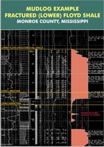
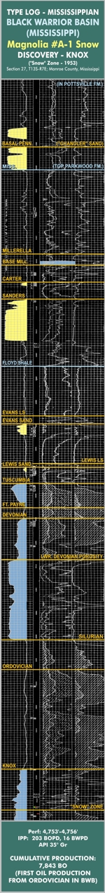
Generally speaking, the Black Warrior Basin thickens from northeast to southwest, with the thickest depositional axis paralleling the NW/SE strike of the buried Ouachita thrust belt. Deposition of thick Pennsylvanian Pottsville sediments marks the period of greatest subsidence in the Basin, not just along the Ouachita perimeter, but also in the extensive transtensional grabens formed in the extreme northwestern counties of Mississippi (especially Tunica and DeSoto Counties). To view a Pennsylvanian Pottsville "Type Log" for the northeast Mississippi portion of the Basin, click here. Modern 2D seismic data indicates wrench faulting and transpressional/transtensional structures are also present in northeastern Mississippi. Practically all of the oil and gas production to date in the Basin has been derived from Upper Mississippian sandstones and Pennsylvanian Pottsville coal seams, with lesser contributions of gas from Pottsville sandstones and from fractured Upper Ordovician carbonates. The Lower Mississippian Floyd Shale, a widespread source rock that is the stratigraphic equivalent of the Fayetteville Shale of the Arkoma Basin, has to date failed to yield commercial rates of gas from many recent "unconventional" shale gas completion attempts, despite the efforts of numerous companies to implement the same drilling and completion methods (horizontal, underbalanced drilling with multistage fracture stimulations) that worked well in similar Paleozoic shale gas plays in other areas. On the extreme eastern perimeter of the Basin, a number of marginal gas completions have recently been made in the shallow Conasauga Shale thrusts of the Gadsden, Alabama area; the economics of this nascent shallow Conasauga gas trend are also unclear, but increasingly doubtful. Accordingly, the Black Warrior Basin - for the time being - remains a "conventional" gas province. To view a Lower Paleozoic "Type Log" for the northeast Mississippi portion of the Basin, click here.
The source of sediments for the important Mississippian sandstone reservoirs of the Black Warrior Basin (Carter, Sanders, Lewis) appears to be the relatively stable cratonic margin of the Nashville Dome (i.e., from the north). The Carter and Sanders sandstones represent a clastic wedge that in northwest Alabama is bracketed between the Millerella Limestone (above) and the Bangor Limestone (below); the Bangor Limestone also serves to demarcate the Upper Mississippian Parkwood Formation from the Lower Mississippian Floyd Shale. The Fort Payne Chert unconformably overlies a thin Devonian Chattanooga Shale at the base of the Mississippian in the Black Warrior Basin, while at the top, the basal transgressive sandstones of the Pennsylvanian Pottsville unconformably overlie the Upper Mississippian Parkwood Formation. The most important sandstones of the Floyd Shale are the Lewis Sand and, in limited areas, the shallower Evans Sand.
By far the most prolific gas reservoirs of the Basin have been the coal seams of the Pottsville. These Pennsylvanian coals have yielded over 2.2 trillion cubic feet of gas, or roughly twice the volume of gas produced by the "conventional" Pennsylvanian and Mississippian sandstone reservoirs, combined. The most important producing "conventional" counties are Lamar, Fayette & Pickens Counties in northwest Alabama and Monroe & Lowndes Counties in northeast Mississippi. The largest "conventional" gas field in the Basin is Corinne Field, located in Monroe and Lowndes Counties in Mississippi; as of December 2009, Corinne Field has produced over 159 BCF of gas and 525,000 barrels of condensate. The largest "conventional" oil field in the Basin is North Blowhorn Creek Field, located in Lamar County, Alabama; as of July 2015, North Blowhorn Creek Field has produced over 6,638,000 barrels of oil.
Well control in the Black Warrior Basin greatly diminishes below the top of the Devonian. Despite this, there has been limited oil and gas production from the Devonian tripolitic chert and the Upper Ordovician, and a Silurian sandstone in the central Basin area (the so-called "Patterson Sand") also has potential for gas production, but is lenticular and poorly understood. The best production from these deeper reservoirs has been derived from the "Knox Ordovician" (Stones River Dolomite) at Maben Field, which has produced over 75 BCF of dry gas from a thick interval of highly fractured, partially dolomitized, "tight" Ordovician carbonates. Generally speaking, the Paleozoic interval beneath the Mississippian in the Black Warrior Basin has been very lightly explored and thus remains a highly prospective and readily accessible gas province.