| MAFLA Formation |
|
|
|
|
|
|
|
|
|
|
|
|
|
|
MS Paluxy Discovery
MOST OF THE TIGHT GAS TREND AREA REMAINS UNDEVELOPED
The Hosston Formation is a thick sand and shale sequence of Lower Cretaceous Hauterivian - Aptian age, and is correlated to be the eastern representative of the Travis Peak Formation of Texas. It can reach a thickness in excess of 1,000 feet within the center of the Mississippi Interior Salt Basin. In general terms, the Hosston depositional environment transitions from fluvial, in east-central Mississippi, to fluvial deltaic in south-central Mississippi, to marine in southwest Mississippi and the Florida Parishes of Louisiana.
Hydrocarbon production from the Hosston Formation was first derived from oil reservoirs located within the updip fluvial sequence (primarily because these reservoirs were located at shallower depths), but the real Hosston Play in Mississippi was kicked off in the 1970's with the discovery of multiple Hosston gas reservoirs within the fluvial deltaic trend in Jeff Davis, Covington, Simpson, and Marion Counties, in south-central Mississippi. This part of the Interior Salt Basin is dominated by salt diapirs, residual salt swells, and interdomal "turtleback" (sedimentary-cored) anticlines. In the 1950's and 1960's, test wells had been drilled atop most of the turtleback anticlines but had for the most part stopped at the top of the Lower Cretaceous (in those days, the Upper Cretaceous Lower Tuscaloosa Formation was the principal target of interest, and little was known about the deeper Lower Cretaceous section). Few of the shallower UK tests were successful, and Hosston completions made elsewhere in the Basin were unimpressive. In addition, steep dips around most of the salt diapirs in the area frustrated attempts to accurately test their narrow flanks.
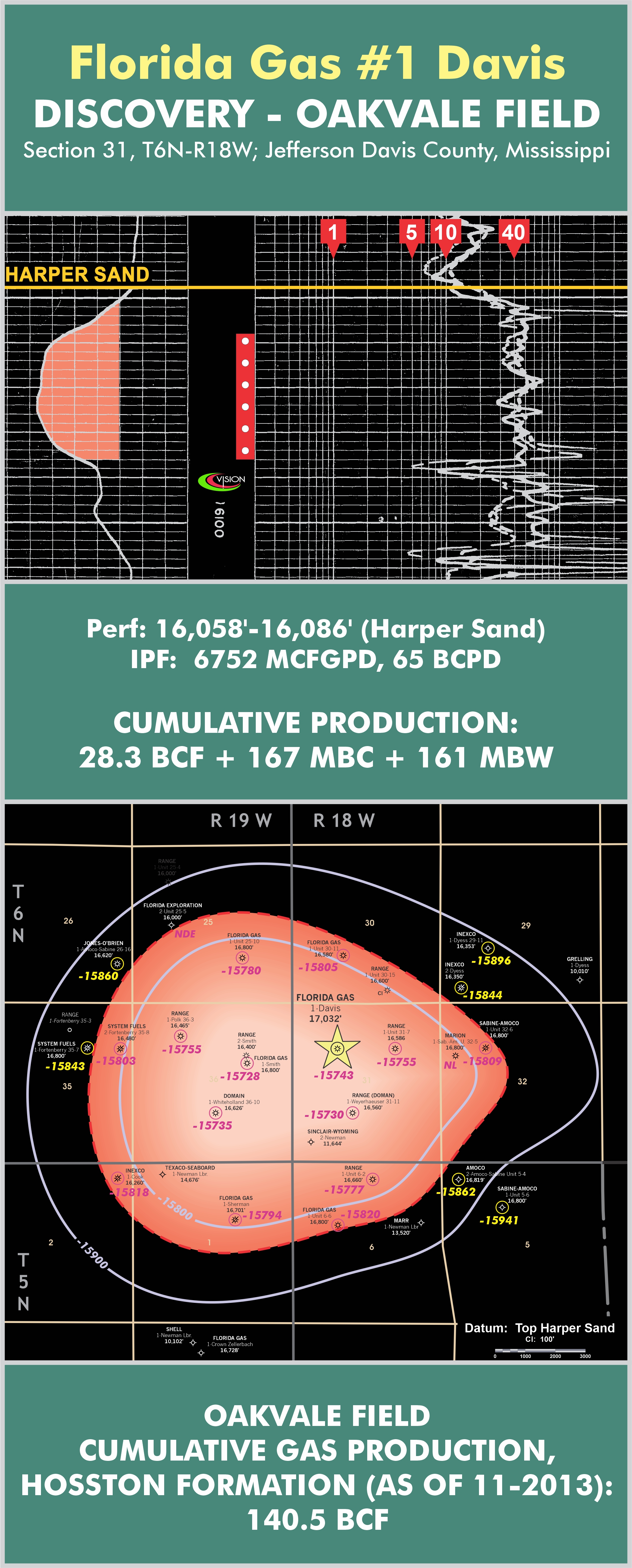
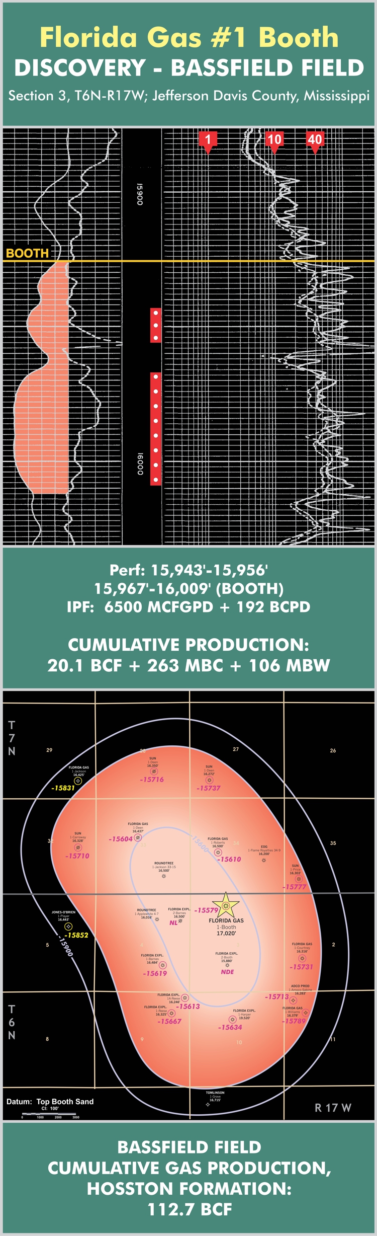
However, in 1974, the discovery of large (>100 BCF) Hosston gas reserves at Bassfield Field in Jeff Davis County, atop a turtleback anticline, created huge momentum for drilling most of the turtleback anticlines deeper. The upward spike in gas prices that occurred later in that decade only further fueled the expanding gas play. Other large fields such as Oakvale, Greens Creek, Grange, White Sand, and Holiday Creek - to name a few - were quickly developed. The collapse of natural gas prices in 1981-1982, which coincided with the maturation of the play and a decrease in new field discoveries, caused the Hosston Gas Play in central Mississippi to quickly fade.
From time to time, however, the industry was reminded of its potential, especially when large Hosston gas reserves were serendipitously discovered at Poplarville Field by Exxon in the mid-1980's. Exxon, in the course of drilling a deep Smackover test on the west flank of the Wiggins Arch (in Pearl River County, Mississippi), stumbled into overpressured gas reserves in over seven different Hosston Sands. Although the deep Smackover objective was found to be nonporous at that location, Exxon's subsequent plug back and completion in two Hosston gas sands eventually led to the production of over 150 BCF of gas from multiple gas reservoirs in the 15 years since that first Hosston completion was made in the Poplarville Field area.
Most of the gas reserves produced from the Hosston in south-central Mississippi have come from the Harper Sand, a very clean and porous sand located in the upper Hosston section. Although some lenticularity is observed throughout the area, the Harper Sand is fairly well distributed and there are many individual Harper Sand gas wells in the trend that have produced in excess of 10 BCF. Also noteworthy is the Booth Sand, which ranks second in total Hosston gas production but is notoriously "dirtier" than the Harper Sand. Specifically, the Booth Sand typically contains much higher concentrations of smectite and illite, and is much more sensitive to drilling and completion fluid rheology. For this reason, many Hosston Booth Sand gas completions - especially those made early on, in the life of the trend - were plagued by high "skin" factors, inefficient drainage, and low cumulative gas production. Other Hosston reservoirs of lesser importance include the First and Fifth Hosston Sands and the Diffrient Sand, which hosts a deep (and rare) Hosston oil pool in the Holiday Creek Field in Jeff Davis County. The trapping style for the Hosston reservoirs in Mississippi ranges from simple anticlinal closures to truncation against salt dome flanks to purely stratigraphic traps formed where a lenticular Hosston Sand crosses a structural nose in a perpendicular fashion.
Maps of Oakvale and Bassfield Fields, along with log exhibits featuring their respective discovery wells, are shown immediately after (below) this discussion.
In the last ten years, a renewed effort to recapture those gas reserves still left in those Hosston reservoirs damaged by early drilling and completion methods - in particular, the significant reserves remaining in the Booth Sand - led several operators to attempt new and innovative completion techniques in several existing fields. One of the most successful of the new approaches is the practice of re-entering a Hosston gas well known to have suffered serious formation damage and plugging back and sidetracking out of the original wellbore above the sand; redrilling the sidetrack hole back to just above the top of the sand; cementing a liner in place; and drilling into the top of the sand with a CO2 foam system, and producing the reservoir as an open-hole completion. This method effectively prevents the exposure of the sensitive Hosston reservoir to water or water-based drilling fluid, a precaution that appears to have paid off; several of these new "water-free" recompletions have resulted in stabilized flow rates in the 2,000 to 3,000 MCFGPD range, which is more impressive when one recalls that in many of those (original) wellbores, production from the same reservoirs had declined to non-commercial (<100 MCFGPD) rates.
Vision Exploration believes that significant gas potential still exists in those deeper Hosston Sands - below the Booth Sand - that were not reached by many of the older Hosston wells drilled in the 1970's and 1980's. These deeper reservoirs have been found to be productive on the flanks of many of the salt domes that have been recently drilled in the Basin. If these deeper sands are productive on the salt dome flanks, they should also be productive on many of the adjacent turtleback and residual structures, because those structures experienced structural growth in the Hosston at the same time as their related diapirs. Vision Exploration has singled out several of these targets for inclusion in its Exploration Program.
Steve Walkinshaw, President, Vision Exploration
This entire site Copyright © 2020. All rights reserved.