
| MAFLA Formation |
|
|
|
|
|
|
|
|
|
|
|
|
|
|
Low Resistivity
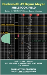
PORT HUDSON FIELD - A LARGE GAS-CONDENSATE FIELD LOCATED NEAR BATON ROUGE, LOUISIANA
Port Hudson Field is the most prolific Deep Lower Tuscaloosa Field discovered to date in the Deep Lower Tuscaloosa Trend of South-Central Louisiana. As of December 2010, the field had produced over 808 BCF of gas and 91,000,000 barrels of condensate. Port Hudson Field is unique within the established Deep Lower Tuscaloosa Trend in that it is a salt-cored high-releif anticlinal closure located just south of the Lower Cretaceous Shelf Edge. While Vision does not have access to the 3D survey acquired by BP Amoco over the Field, it is suspected that, as a response to dramatic depositional loading, an allochthonous mass of Louann Salt moved up the fault plane(s) of one or more large down-to-the-coast faults that delineate the great syndepositional expansion of Lower Tuscaloosa sediments south of the Shelf Edge, forming the Port Hudson anticline. Because the Port Hudson Lower Tuscaloosa sandstone reservoirs are trapped as "shallow" as 15,400 feet subsea, the field pays fall within the gas-condensate "window" for the Deep Lower Tuscaloosa Trend, which explains why Port Hudson has produced far more condensate than all of the other (much deeper and "dryer") Deep Lower Tuscaloosa Trend Fields, combined. To learn more about the greater Lower Tuscaloosa Trend, please click here.
Dramatic structural thinning within the Lower Tuscaloosa is observed as one moves from studying wells drilled in an off-flank position to those wells drilled atop the broad crest of the Port Hudson anticline. This means that some flank reservoirs pinch out or are truncated by salt before they reach the crest. While both the Stringer and Massive Sand equivalents produce at Port Hudson Field, the majority of the gas has been produced from the Massive Sand facies. Shown below is Vision's Subsurface Map contoured on the Top Lower Tuscaloosa / Base TMS "Bain" Marker. ADVISORY: this map is being provided solely for informational purposes; accordingly, in no event and under no circumstances will Vision Exploration be liable for any claim of damages of any kind related to the unauthorized use of this map or its contents, which is expressly forbidden without our permission in writing. Please respect our good-faith efforts to inform and educate, and be sure to read our Disclaimer. Thanks.
![]()